|
|
|
|
|
Certification


- I'm Online Chat Now
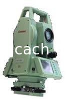
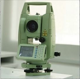
Sanding WINCE reflectorless total station STS-772RC touch screen
Product Details:
Payment & Shipping Terms:
|


Detailed Product Description
| Model: | Sanding WINCE Reflectorless Total Station STS-772RC Touch Screen |
|---|
Sanding STS-772RC Series Laser Prism Windows CE total stations, a variety of measurement procedures, adapt to a variety of measurement environment.
![]()
Basic parameters :
Angle measuring principle: Absolute Encoder
Angle measurement accuracy: 2 "
Range (no prism): 350m (single prism 5000m)
Ranging Accuracy: 2mm +2 ppm
Display: 3.2-inch color screen, Windows CE operating system
Dust and Moisture: IP55 (according to the standard: IEC60529)
Features :
STS-772R Total Station, the world's leading technology, excellent manufacturing process, to adapt to a variety of measurement environment: heat, cold, rain; competent major measurement tasks: mapping, engineering, construction.
Excellent protection and environmental adaptability of the instrument in a variety of complex work under harsh operating conditions stable as usual, at any time to ensure the reliability of measurement results, to ensure maximum efficiency.
Sanding optical products as one of the top, STS-772R Total Station with:
Windows CE operating system, the total station can be realized on a computer operation;
Convenient data communication, U disk directly import / export data, and other USB peripherals directly to computer and communications;
Extensive measurement program to facilitate the measurement of work;
Free Prism 350m, eliminating the pain of erecting prism;
Equipment installed powerful mapping wizard series of software, but also supports user self measurement program.
Measurement procedure
Let stand free wherever you need it most total station placement, measured using the program calculates the three-dimensional coordinates of the site and set directional azimuth.
Can use up to five known points in the calculation as a back sight , observations can be single or double-sided observation angle and distance values.
Stake out stake out points from the field data can be entered, you can also call the Total Station memory data. Memory data can be uploaded and stored in a computer in the total station. At the same time you can view polar, orthogonal coordinate difference and stake out the error value.
Reference line / arc a variety of building applications this program to the line, the road straight part of the loft and check, and excavating a straight line to guide the work of a huge convenience. Guides can also be required translation, rotation adjustments.
Axis is the axis of loft building construction site layout, building the basis for all the points are based on its relative position with the axis to be loft to. Lofting process, apparatus, prism point and stake out the relative positions of the axis has a graphical display.
REM prism can not reach some measured point can be aimed directly at the point just below the base of the prism, measuring horizontal distance, then aim at the high point of suspension, measure the height difference measured point. Can be used to measure high-voltage lines, bridges and other structures of the high clearance.
Area measurement area measurement program can measure real-time connection between the target point surrounded the area and perimeter. No limit to the number of points target, in the calculation of the point measured in real time, from memory, selected in the scene can also be entered from the keyboard.
Road design and lofting can use a straight line, arc, curve and ease the four elements of the intersection of the road plane and elevation edit the design value. Road stakeout functions can be convenient to set based on road mileage Stake in piles, piles and slope-side location of the border.
Contact Details
Shanghai Magcach Technology Co.Ltd
Contact Person: Ms. Rebecca Zhou
Tel: +86-18221338069
Other Products
-
China Brand new Mato Total Station MTS1202R Reflectorless Total Station 500m to 800m
-
China Brand new Mato Total Station MTS602R Reflectorless Total Station 400m to 500m
-
China Brand new Mato Total Station MTS802R Reflectorless Total Station 400m to 500m can be with SD card
-
China Brand FOIF Total Station Rts 352 Windows Ce/ Fieldgenius Software (RTS352/355-R500/R1000)
-
CHC CTS-112R4 Total Station
-
Mato MATO MTS102R Classical Total Station reflectorless Total Station