|
|
|
|
|
Certification
- I'm Online Chat Now
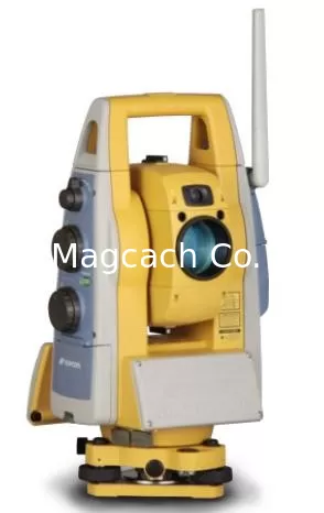
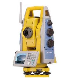
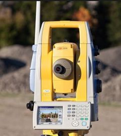
Topcon IS 301 total station imaging IS301
|
Product Details:
Payment & Shipping Terms:
|


Detailed Product Description
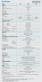
| None Prism Distance: | 2000m | Accuracy: | 1" |
|---|
Topcon IS 301 total station imaging IS reflectorless Distance 2000m
![]()
Quick Details
Place of Origin: China (Mainland)
Brand Name: Topcon
Model Number: IS 301
Accuracy: 1''
Method: Absolute Reading
Minimum Reading: 1"/5"
Compensating: Dual Axis
Compensating range: ±6'
1 prism: 3000m
3 prisms: 4000m
9 prisms: 5000m
Non-prism long model: 5m-2000m
Packaging & Delivery
| Packaging Details: | Original package |
| Delivery Detail: | Within 5 days after received 100% payment |
Product Description
Scan with live images
2000m(6,500ft) reflectorless measurement
Remote image display by TopSURV and Image Master
Powerful X-TRAC 8 Auto-Tracking Technology
3Two Digital Cameras - wide angle and 30X tele-zoon
The high-speed scan"Grid Scan"
The high speed measurement Grid Scan obtains 3D data by automatic scanning at a specified pitch within a specified area. Using Topcon's image analyzing software, 3D models can be created from the data.
Easy Scan Mode
Easy Scan Mode is employed to maximize the simplicity of scanning workflow.
With a standardized procedure flow, scans can be completed with enhanced work efficiency.
"Feature Scan" to assist area measurement
This method automatically extracts features (corners) from the image of a specified area. Together with the Grid Scan, it greatly enhances performance on every job.
Image Master for IS
With Image Master, TIN images can be formed from 3D point cloud data. Using TIN data, it is possible to create texture-mapped 3D data, which are available for various usages including calculating surface area, calculating volume, and measuring distance.
Remote Operation of IS
Image Master provides image and scan control of the IS through WLAN connection using the internal WLAN module. Remote operation is at your fingertips.
X-TRAC 8 - Advanced Auto-Tracking Technology
New X-TRAC 8 technology provides extremely quick and powerful auto-tracking capability even under the harshest environments, enabling dramatic increase of one-man survey efficiency.
Extremely powerful X-TRAC 8 technology provides:
1,000m long-range auto-tracking capability.
Accurate tracking even in most obstructed sites or with intensive sunlight.
RC-4 QuickLock remote option enables rapid prism search and lock for one-man survey.
Increasing Communication Stability
The WT-100 acts as an access point for the IS instrument and a field controller, increasing stability of data and image transmission. The IS can be operated from distance of up to 300m(1,000ft) using real-time digital camera images on a field controller's screen.
*The range of wireless transmission varies according to the environmental status such as barriers and obstacles. Direct the antenna of the WT-100 toward the IS for seamless communication.
Two Built-in Digital Cameras -Wide Angle and Tele-Zoom
You can view the surrounding area and focus on the object with the wide angle camera and use the tele-zoom through 30x optical lens for the precise collimation. The clear tele-zoom image is displayed through the automatic focus adjustment. The images are stored in the internal memory as well as being displayed on the screen.
One-man Survey System - QuickLock and stable WLAN connection
When combined with a data collector and RC-4 system, the IS is perfect for a one-man survey system. The IS represents the third generation of Topcon's world's first QuickLock technology. By just pressing a button, the RC-4 reacquires the IS again easily and quickly. With its stable WLAN connection, and smooth, fast live video operation, the IS ensures a stress-free, efficient survey.
Continuous Monitoring
Whether done with mounted prisms or reflectorlessly, this monitoring function compliments the everyday use function of our robotic surveying.
"Touch Drive" to handle the instrument
Touching the object on the image causes the instrument to rotate to the tapped object. The telescopic-view image provides zoom display with the same view angle of telescope. The Touch Drive also enables pinpoint measurement that allows the accurate collimation just like looking in the telescope.
"Application Software
ImageMasterSuites(Optional)
Image Master Pro
Complete version of Image Master Suites.In addition to all the functions of Image Master Std, strong 3D Photogrammetry measurement by digital cameras is supported.
Image Master Std
Upgrade version of Image Master for IS. Survey tools like Contour Line, Cross Section, Area, Volume calculations are supported.
![]()
Contact Details
Shanghai Magcach Technology Co.Ltd
Contact Person: Ms. Rebecca Zhou
Tel: +86-18221338069
Other Products
-
China Brand new Mato Total Station MTS1202R Reflectorless Total Station 500m to 800m
-
China Brand new Mato Total Station MTS602R Reflectorless Total Station 400m to 500m
-
China Brand new Mato Total Station MTS802R Reflectorless Total Station 400m to 500m can be with SD card
-
China Brand FOIF Total Station Rts 352 Windows Ce/ Fieldgenius Software (RTS352/355-R500/R1000)
-
CHC CTS-112R4 Total Station
-
Mato MATO MTS102R Classical Total Station reflectorless Total Station